 Google Maps is one of the most popular map services on the Internet. It can be used for several purposes including looking at maps at different zoom levels in the world or to get directions by entering two locations.
One problem that many users experience when using Google Maps is the inability to create maps that do not fit on the computer screen. This usually means to take a screenshot of each part of the map and either keep them as separate images on the computer or to join them together in an image editor. Both options are not very comfortable.
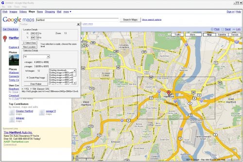
A better solution is the portable software Google Map Buddy which allows the user to download and join any area in Google Maps. The program does that by opening Google Maps in its interface. All navigational options are provided which means it is possible to find a location in the world by searching for it or to get directions by using that feature.
The program offers a small control overlay that can be used to draw a rectangle on the map. This rectangle will be downloaded and joined together later on.

There are two additional steps after drawing the rectangle on the screen. The first is the selection of the zoom level. A higher zoom level results in greater detail but also in additional images that are downloaded and joined in the end. The program will display the number of images that are created. There is also a visual aid if the Draw Helper button is pressed.
The Create Map Image will start start downloading the selected area from Google Maps to the location specified by the user in the file browser. The map parts will be downloaded separately at first and joined in the end. It is furthermore possible to keep the single map images or delete them in the end.
Google Map Buddy is a helpful program for users who want to download or print maps from Google Maps without having to join them afterwards. It is for instance possible to create a detailed map of a specific town or location which would take a long time to create manually due to the many screens it would be displayed on.
Tags: Google, google map, google map buddy, google maps, maps, maps google, portable software, windows software
Related posts
"
No comments:
Post a Comment